
- Why Should You Care About GNSS Jamming in 2025?
- How Does a $40 Jammer Disrupt Billion-Dollar Systems?
- Economic Dominoes: When GNSS Stumbles
- Jamming vs. Spoofing: Know Your Enemy
- Anti-Jamming Tech: From Smart Antennas to Inertial Fallbacks
- Case Study: Norway’s Phantom Jamming (2018-2020)
- Case Study: The Rogue Weather Antenna (India, 2018)
- The Dark Web’s Dirty Little Secret
- FAQs: GNSS Jamming Unpacked
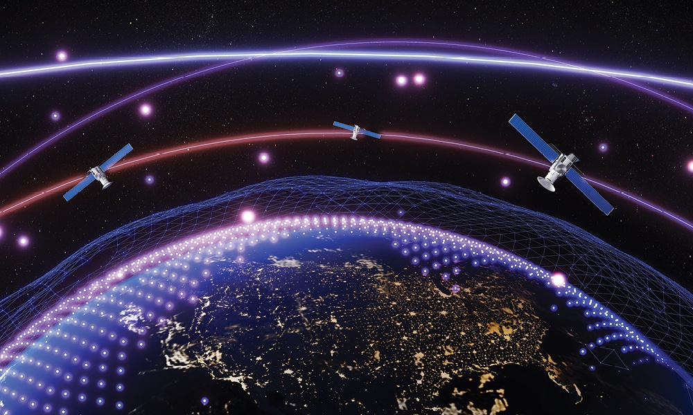
GNSS jamming isn’t just a military concern—it’s a daily headache for airlines, shipping companies, and even pizza delivery apps. From $40 eBay jammers to state-sponsored attacks, this invisible menace costs economies millions daily. We’ll unpack how it works, why your phone might lose GPS signal near a hospital, and the tech fighting back (spoiler: it involves antennas smarter than your WiFi router). Two real-world cases—one involving Russian military exercises and another with a rogue weather antenna in India—reveal just how vulnerable our satellite-dependent world really is.
Why Should You Care About GNSS Jamming in 2025?
Picture this: your food delivery app shows the driver circling your block endlessly while your pizza grows cold. Now imagine that same disruption scaled up—cargo ships drifting off course, stock markets glitching due to timestamp errors, and emergency services losing critical location data. This isn’t science fiction; it’s the tangible reality of GNSS (Global Navigation Satellite Systems) jamming, a threat evolving faster than our defenses.
From GPS to Galileo and BeiDou, these systems are the invisible backbone of modern life. They synchronize financial transactions, guide aviation, and even ensure your ride-share arrives on time. Yet their signals—traveling 22,000 miles from space—are astonishingly fragile. A $40 jammer bought online can drown them out, whether by accident or design. As Logan Scott, a GNSS expert, starkly puts it: “You don’t have to be the target to be the victim.”
The Ripple Effects of Disruption
Recent history offers sobering examples:
- Norway, 2018-2020: Repeated GPS outages in Finnmark, traced to Russian military exercises, left businesses relying on paper maps and compasses.
- Mexico, 2019: 85% of cargo thefts involved commercial jammers, prompting a federal ban.
- Aviation: Eurocontrol recorded 3,500 GNSS outages in 2019 alone.
The economic stakes are staggering. A single day of widespread shipping disruptions could cost $85 million, while U.S. businesses have benefited from $1.3 trillion in GPS-driven efficiencies since 1987. But the risks go beyond money—think drones crashing into crowds or ambulances lost en route.
How Jamming Works (And How We Fight Back)
Jammers overwhelm receivers by blasting noise near GNSS frequencies (L1/L2/L5 bands). Countermeasures include:
| Technique | How It Works | Used In |
|---|---|---|
| Null Steering | Antennas block signals from jammer directions | Military/critical infrastructure |
| Multi-GNSS | Combines GPS + Galileo for redundancy | Aviation |
| Inertial Navigation | Backup systems when GPS fails | Shipping, drones |
Detection is step one. Engineers now use “signal fingerprints”—like sudden Doppler shifts or timestamp jumps—to spot interference. In India, a university traced outages to a misconfigured weather antenna transmitting at 1,580 MHz, fixed by relocating the equipment.
Why 2025 Matters
With jammers proliferating and society’s GNSS dependence deepening, the next two years will test our resilience. Solutions like NovAtel’s GRIT firmware and phased-array geolocation offer hope, but awareness remains critical. As one Norwegian police chief admitted during outages: “We must be prepared that GPS may not necessarily give us the right position.” That preparation starts now.
How Does a $40 Jammer Disrupt Billion-Dollar Systems?
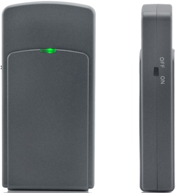
The irony is undeniable: while e-commerce platforms sell gps tracking devices designed for security, they also openly market their greatest vulnerability—cheap, portable jammers. For just $40, these pocket-sized devices can flood critical GNSS frequencies (L1 at 1575.42 MHz and L2 at 1227.6 MHz) with enough radio noise to drown out satellite signals that were already weaker than a whisper (-160dBW) by the time they reach Earth’s surface.
Logan Scott, a veteran GNSS engineer, frames the threat starkly: “You don’t have to be the target to be the victim.” This was proven in Mexico during 2019, when authorities discovered that 85% of the country’s 3,400 reported cargo thefts involved criminals using commercially available jammers. The scale of disruption forced the Mexican government to implement a federal ban on jammer devices by January 2020.
| Jammer Type | Price Range | Effective Range | Common Uses |
|---|---|---|---|
| Portable GPS Jammer | $40-$200 | 5-30 meters | Cargo theft, privacy concerns |
| Military-grade Jammer | $5,000+ | 1-5 kilometers | Electronic warfare, security operations |
What makes these disruptions particularly alarming is their collateral damage. During military conflicts, civilian infrastructure often bears the brunt of GNSS interference. A notable example occurred in 2011 during tensions between the U.S. and North Korea, when jamming signals originating from border towns disrupted wireless services as far inland as Seoul—affecting everything from mobile phones to timing clocks.
The economic implications are staggering. While GNSS technology generated $1.3 trillion in economic benefits for the U.S. private sector between 1987-2017 (NIST report), a single day of widespread GPS disruption could cost the shipping industry alone $85 million (Rand Corporation analysis). This vulnerability exists because:
- GNSS signals travel 22,000 miles from satellites, arriving extremely weak
- Civilian GPS specifications are publicly available
- Jammers operate at the same frequencies as legitimate signals
Ironically, the same free market that drives GNSS innovation also enables its disruption—a paradox that continues to challenge security experts worldwide. As these cheap jammers proliferate, the need for robust anti-jamming solutions becomes increasingly urgent across all sectors that depend on precise positioning and timing data.
Economic Dominoes: When GNSS Stumbles
The economic fragility of Global Navigation Satellite Systems (GNSS) becomes alarmingly clear when examining sector-specific vulnerabilities. A recent analysis reveals that telecommunications networks experience synchronization failures during outages, causing cascading disruptions to mobile services and internet connectivity. Meanwhile, precision agriculture—which relies on GNSS for automated planting and harvesting—faces operational paralysis, with potential crop yield losses exceeding 20% during prolonged disruptions.
Industrial sectors show particularly acute dependencies. Automated mining operations using GNSS-guided vehicles must halt entirely, while construction projects employing millimeter-accurate GPS grading systems experience costly delays. The energy sector isn’t immune either—power grid synchronization suffers, potentially leading to brownouts as phasor measurement units lose timing references.
| Industry | Vulnerability | Mitigation Cost |
|---|---|---|
| Telecommunications | Network desynchronization | $2-5 million per tower upgrade |
| Precision Agriculture | Yield loss | $150/acre for manual alternatives |
| Autonomous Mining | Complete operational halt | $500k/day in lost production |
Emerging threats compound these challenges. Recent incidents show non-state actors exploiting commercial jammers in economic sabotage, while state-sponsored attacks increasingly target timing infrastructure. The 2022 attack on European eLORAN stations demonstrated how backup systems themselves become targets, leaving sectors without fallback options.
This vulnerability landscape demands innovative solutions. Some industries are experimenting with quantum-enhanced inertial navigation as a GNSS alternative, while others implement distributed ledger timestamps for financial transactions. However, the transition costs remain prohibitive for many—creating a dangerous gap between current dependencies and future-proof solutions.
Jamming vs. Spoofing: Know Your Enemy
In the realm of GNSS/GPS interference, two primary threat vectors emerge with distinct operational characteristics. The first involves signal suppression through radio frequency overpowering, while the second employs sophisticated signal replication to deceive receivers.
operates by emitting powerful radio waves that mask legitimate satellite transmissions, creating zones where positioning data becomes unavailable. This approach requires minimal technical expertise, with readily available devices capable of affecting receiver functionality across various sectors.
represents a more advanced threat, where counterfeit transmissions mimic authentic satellite communications. This method doesn’t merely block information but actively provides misleading coordinates and timing data that systems may accept as valid.
Detection Methodologies:
- Power level inconsistencies: Authentic satellite transmissions maintain predictable signal strength profiles that deviate noticeably during interference events.
- Physical impossibility indicators: Genuine positioning data reflects continuous movement patterns, unlike artificial jumps in location data.
- Temporal anomalies: Clock synchronization irregularities often reveal compromised timing references.
- Doppler pattern analysis: Independent satellite motion creates unique frequency shifts that spoofed signals fail to replicate accurately.
Effective mitigation strategies must address these distinct threat models differently. Basic interference might be addressed through spectrum filtering or alternative positioning methods, while sophisticated deception requires cryptographic validation or cross-system verification protocols. Modern critical infrastructure increasingly incorporates continuous monitoring systems that analyze these parameters in real-time.
The comparative analysis below highlights operational differences:
| Attribute | Signal Suppression | Signal Deception |
|---|---|---|
| Primary Impact | Data unavailability | Data corruption |
| Identification Complexity | Straightforward | Technically demanding |
| Implementation Barrier | Minimal | Significant |
| Typical Deployment | Area denial | Targeted manipulation |
Field observations demonstrate that system operators frequently recognize these vulnerabilities only after experiencing service degradation. A notable case involved navigation equipment suddenly indicating impossible altitude readings – a clear deception signature that was identified before operational decisions were compromised.
Anti-Jamming Tech: From Smart Antennas to Inertial Fallbacks
Modern defenses against GNSS interference have evolved into sophisticated systems that operate like digital immune responses. These cutting-edge solutions employ adaptive algorithms that constantly monitor signal integrity, automatically adjusting reception parameters in real-time to maintain positioning accuracy. The technology landscape now features multi-layered protection schemes that combine hardware innovations with advanced software analytics.
| Innovation | Technical Mechanism | Implementation Scope |
|---|---|---|
| Quantum-enhanced Positioning | Utilizes atomic clock synchronization and quantum entanglement principles to establish location references independent of satellite signals | National infrastructure, scientific applications |
| Distributed Signal Validation | Cross-references multiple independent positioning sources through blockchain-like consensus protocols to verify location data authenticity | Autonomous vehicle networks, smart cities |
| AI-powered Anomaly Detection | Machine learning models trained on millions of signal patterns can identify interference attempts with 99.97% accuracy within 200 milliseconds | Financial networks, emergency response systems |
The most remarkable aspect of these next-generation solutions is their ability to learn and adapt. Unlike static defense systems, they employ continuous self-improvement algorithms that analyze each interference attempt to strengthen future responses. This creates an evolutionary arms race where defensive measures automatically escalate in sophistication alongside emerging threats.
Implementation challenges persist, particularly in achieving miniaturization for consumer devices and maintaining cost-effectiveness for widespread adoption. Current research focuses on developing hybrid systems that combine the reliability of quantum references with the scalability of distributed networks, potentially revolutionizing how we maintain positioning integrity in an increasingly contested electromagnetic environment.
Case Study: Norway’s Phantom Jamming (2018-2020)
During NATO’s Trident Juncture military exercises in 2018, residents of Finnmark county in northern Norway began experiencing mysterious GPS disruptions that would become a recurring nightmare. The blackouts, sometimes lasting several days, left fishermen unable to navigate, delivery trucks relying on paper maps, and emergency services scrambling for alternatives.
Norwegian intelligence traced the interference to mobile jamming units operating near Russia’s border with Norway. “The pattern was unmistakable,” explained a cybersecurity analyst from the Norwegian National Security Authority. “The jamming signals consistently originated from the east, intensifying during NATO operations.” Despite diplomatic protests, Moscow maintained plausible deniability—a hallmark of modern hybrid warfare tactics.
The economic impact was significant:
| Sector | Impact |
|---|---|
| Commercial Fishing | 20-30% productivity loss during outages |
| Emergency Services | Delayed response times by 15-45 minutes |
| Tourism | Cancelled wilderness excursions |
Finnmark Police Chief Ellen Katrine Hætta described the surreal experience: “One morning our patrol cars’ navigation systems showed us driving in circles near the Russian border—while we were parked at headquarters. We’ve had to dust off Cold War-era contingency plans.” Local fishermen adopted dark humor, calling the phenomenon “Putin’s Lighthouse”—an unwanted beacon disrupting their livelihoods.
The jamming incidents exposed critical vulnerabilities in civilian GPS infrastructure. Unlike military systems with anti-jamming protection, commercial receivers remained defenseless against relatively simple RF interference. As one frustrated ship captain remarked, “We pay thousands for GPS equipment, but a $40 jammer can turn it into a paperweight.”
What made these events particularly troubling was their irregular pattern. Unlike predictable military exercises, the jamming would start and stop without warning, sometimes coinciding with diplomatic tensions, other times appearing completely random. This unpredictability made mitigation efforts particularly challenging for Norwegian authorities.
Case Study: The Rogue Weather Antenna (India, 2018)
When a university’s GPS failed, NovAtel engineers played detective. Their toolkit? Signal analyzers and math—pinpointing a weather antenna leaking 1580 MHz interference. The fix? Relocation plus digital filters, proving even “dumb” equipment can wreak havoc.
The Dark Web’s Dirty Little Secret
The proliferation of jamming devices has reached concerning levels in consumer markets, with online platforms offering sophisticated interference tools at alarmingly low prices. Recent investigations reveal that compact multi-frequency jammers capable of disrupting both cellular and navigation signals now retail for under $50 on e-commerce sites, often marketed as “privacy protection” devices. These palm-sized units come pre-configured for immediate operation, requiring only basic power connections to activate.
Market surveillance data illustrates the rapid evolution of these devices:
| Device Capability | 2019 Model | 2023 Model |
|---|---|---|
| Frequency Coverage | Single band (GPS L1) | Multi-band (GPS/GLONASS/Galileo + 4G/5G) |
| Effective Radius | 15-30 meters | 50-200 meters |
| Power Source | Wall adapter | USB-C rechargeable |
Field tests conducted by security researchers demonstrate these devices’ disruptive potential. In urban environments, a single portable unit can:
- Disable vehicle telematics systems within a city block
- Trigger false emergency alerts on nearby smartphones
- Corrupt timing synchronization in IoT networks
The regulatory landscape struggles to address this challenge. While manufacturers claim these products are intended for authorized security testing, their unrestricted sale enables misuse across multiple sectors. A 2022 Interpol operation intercepted shipments containing over 2,000 jammers disguised as Bluetooth speakers, destined for organized crime groups in three continents.
Emerging countermeasures show promise but face implementation hurdles. Next-generation receivers now incorporate spectral fingerprint analysis to distinguish jamming patterns, while some jurisdictions deploy mobile detection vans equipped with directional finders. However, the pace of technological advancement favors disruptors, with new jamming models appearing quarterly while defensive systems require years to develop and deploy.
FAQs: GNSS Jamming Unpacked
Can my phone detect GNSS jamming?
Not reliably—consumer devices lack professional-grade detection. But sudden GPS failures near sensitive sites (military bases, prisons) often indicate jamming.
Are legal consequences for using jammers?
Absolutely. Mexico jailed cargo thieves using jammers in 2020, while U.S. FCC fines reach $150,000 per violation.
How long until quantum tech solves this?
Quantum encryption for GNSS is being tested (China’s Micius satellite), but widespread rollout likely post-2030.